
This activity can be adapted for all grade bands.
Overview
Hands-on visual art activities are a good way for students to engage with the content about AbenakiHistorically, this name was used by the French to refer to many different Indigenous communities in Vermont, New Hampshire, and Maine. During the colonial wars, some New England Indians moved to southern Canada as war refugees. They were joined by refugees from other tribes and together became known as Abenaki. (Calloway, 1994) culture while enhancing comprehension and retention of the material. Integrating art into the American AbenakiAbenaki tribes, families, and people who live in the United States. Vermont has four recognized Abenaki tribes; for more information visit Abenaki Alliance. Curriculum fosters a deeper understanding of complex regional history.
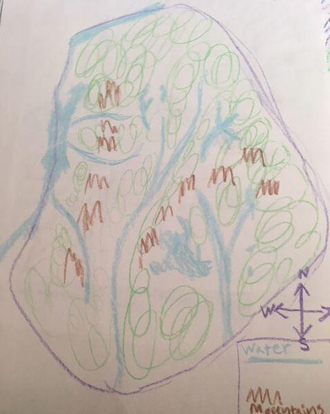
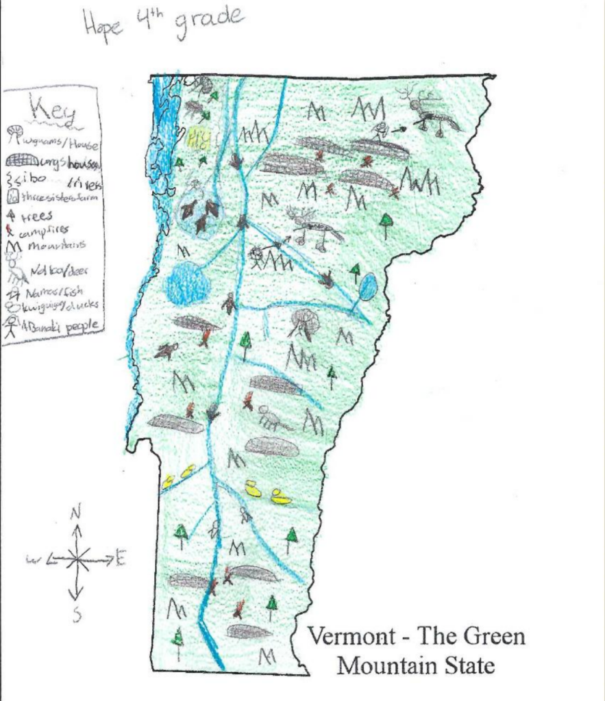
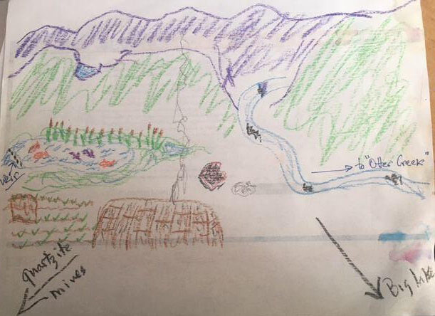
During this activity, students will examine a topographical map and a map of the Abenaki homelands. Then they will draw their own maps of the Abenaki homeland and how it has changed over time. In the process, students will gain map making skills and learn about historical connections, relationships, and geographic influences within the context of Abenaki tribes.
Materials
- drawing paper or you may find a printed outline of the state online
- colored pencils or markers
Worksheets
There are no worksheets needed for this activity.
Resources:
- Alnobak: Wearing Our Heritage(Related term: cultural heritage) Something that is inherited from previous generations and passed along to future generations. It includes family identity, cultural practices, values, and traditions. [Study Guide—page 4] (Sheehan et al., 2019)
- National Geographic Map Maker [Digital interactive] (National Geographic, 2022)
- Native Land Digital [Digital interactive] (Banaszak, 2022)
- Vermont Topography [Road atlas of USA and Canada] (Vermont Topography Terrain Map Topographic State Large Scale Free Detailed Landscape, 2025)
Guiding the Inquiry1. Inquiry is asking questions, seeking knowledge, and investigating information. According to the C3 Framework, inquiry is at the heart of social studies. 2. A comprehensive curricular unit designed for the C3 Framework that includes the key components of questions, tasks, and sources. The inquiry format leads students through the investigation of a compelling question.
- Warm up the class with a discussion to ensure students understand the words relationships, geographyThe study of places on Earth, their features, and the people who live there. , and landforms.
- Explain that they will make maps to show Abenaki relationships in the Abenaki homelands.
- Hand out map-making materials. Provide younger students with a map outline. Older students can draw their own outlines.
- Using Vermont Topography as a reference, have students add landforms and natural features to their maps. Challenge them to consider where the Abenaki people might live and how they might interact with each other and other neighbors based on the geography.
- Have students add a compass rose showing the four cardinal directions.
- Introduce the conceptAn abstract idea, a mental construct, a name, or label that helps people make sense of the world. of a map key and guide students to use shapes, colors, and symbols to represent various features.
- Consider having students draw lines to show where tribes may have traveled for trade.
- Use your classroom routines to determine how students share their maps with others.
Sample Student Responses and Categories

See Historical Context essay and Resources for additional potential responses
Standards Alignment
Click + to view Standards Alignment guidance. Click – to close the box when done.
Potential Alignment: National Core Arts Standards for Visual Arts
The Visual Arts Integration—Make a Map activity can support the following sampling of standards and serve as a starting point for integrating the American Abenaki Curriculum with visual arts instruction and assessmentA tool to measure what a student knows and can do..
Grades 3–5
VA:Cr2.3.3a. Individually or collaboratively construct representations, diagrams, or maps of places that are part of everyday life.
VA:Cr2.3.4a. DocumentTo provide evidence of claims with supporting materials. , describe, and represent regional constructed environments.
VA:Cr2.2.5a. Demonstrate quality craftsmanship through care for and use of materials, tools, and equipment.
Middle School
VA:CR2.1.6a. Demonstrate openness in trying new ideas, materials, methods, and approaches in making works of art and design.
VA:CR2.3.7a. Apply visual organizational strategies to design and produce a work of art, design, or media that clearly communicates information or ideas.
VA:CR3.1.8a. Apply relevant criteria to examine, reflect on, and plan revisions for a work of art or design in progress.
High School (ProficientDescribes when a learner can demonstrate knowledge or skill as described in a grade level standard. level)
VA:Cr1.1.Ia. Use multiple approaches to begin creative endeavors.
VA:Re.7.2.Ia. Analyze how one’s understanding of the world is affected by experiencing visual imagery.